Tiffin's Early
History
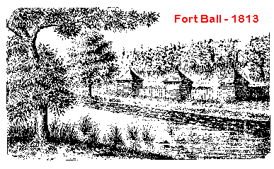
On November 18th, 1817, Erastus Bowe
arrived at Fort Ball, located on the left bank of the Sandusky River in
what is now Tiffin. Bowe brought with him two other hired men. Together
they erected a double log cabin - the first permanent log house within
Seneca County. This building, the Pan Yan, stood in what is now the middle
of North Washington Street. As a tavern and hotel, the Pan Yan offered
respite to weary travelers. Thus began the settlement of what later became
known as Tiffin and Seneca County.
 Bowe
had chosen the location for his venture while serving in the military during
the War of 1812. When visiting the stockade of Fort Ball, the native Virginian
recognized the potential of locating a stop-over point for travelers using
the newly built military road between Upper and Lower Sandusky. Here was
a perfect location for an inn, being one day’s travel from either location.
Bowe
had chosen the location for his venture while serving in the military during
the War of 1812. When visiting the stockade of Fort Ball, the native Virginian
recognized the potential of locating a stop-over point for travelers using
the newly built military road between Upper and Lower Sandusky. Here was
a perfect location for an inn, being one day’s travel from either location.
Not The First
Bowe was by no means the first white
man to traverse the Sandusky area. As early as 1689-90 the French missionary,
Father Pere Rasles, passed through the area. Rasles, a devout man and a
scholar, spent his time converting and ministering to the Indians, eventually
publishing a dictionary of the Abenaquis Indian language. He returned east
and was killed during an attack upon the Indians by a British force in
1724 in New England.
The river’s name may well have been
derived from one of the earlier visitors to the area. Many scholars believe
that “Sandusky” is an Indian word (possibly meaning “cold water”). However,
Jacob J. Greene writing on February 28, 1842 to the American Historical
lournal suggested that “Sandusky” was not an Indian name but, rather, “...
a Polish trader, by the name of Sandusky, or more properly spelt [sie]
Sanduski [who] established himself near the present site of Lower Sandusky
[Fremont], at the foot of the rapids of the river:”
According to the account, Sanduski
fled the Sandusky valley after a violent quarrel with the Indians. A number
of them hotly pursued him all the way back to Virginia and killed him.
In November, 1776, an Irish Tory, Capt.
Matthew Elliott was forced by his loyalist convictions to move west, behind
British lines. He was encamped along the Muskingum River with his Indian
squaw wife and another man named John Leith. The three were surprised and
overcome by a half dozen Indians who confiscated Elliott’s supplies. Luckily,
he escaped and made his way through the Sandusky territory to Detroit.
Elliott and another notorious figure of the Northwest Territory, Alexander
McKee, were commissioned by the British as spies. There is little doubt
that both men were present at the torture and burning of Colonel Crawford
near Upper Sandusky a few years later.
In June, 1782, Col. William Crawford
led a combined force of Virginians and Pennsylvanians northwest in an ill-fated
campaign against the Wyandot stronghold at Upper Sandusky. John Leith (previously
mentioned) was living with the Wyandots at that time. He packed his valuables
and fled north away from Upper Sandusky so as to avoid the army. Leith
was known to have camped along the Sandusky River fourteen miles above
Upper Sandusky - perhaps the first white man to remain within Seneca County
for any period of time. After the Revolutionary War, he returned to Pittsburgh,
but a few years prior to his death in 1832, he again returned to Seneca
County.
Between the Revolutionary War and the
end of the War of 1812, many who traveled through the area were traders
or in the military, most of whom never returned to settle. However, there
was another group of white Americans who were important to the settling
of this Sandusky River Valley, the captives. The treaty of the Miami of
the Lake, negotiated in September, 1817 gives information of interest to
county historians, for within the provisions of the document are the names
of the Indian captives who were to be freed. Many of them had intermarried
with the Indians and, rather than return east, became among the first citizens
of Seneca County.
The Beginning
It was two months after this treaty
was signed that Erastus Bowe built his cabin at the edge of the Sandusky
River. When it was complete, Bowe went back to Delaware County, Ohio, to
gather his family and possessions. In June, 1818, he returned to the Pan
Yan with his wife and newborn son, Erastus G. Bowe. The settlement began
to grow.
In 1819, Paul D. Butler erected the first saw-mill in the county -- just
a few hundred yards south of Bowe’s tavern, near the intersection of what
is now Miami Street and Frost Parkway.
In 1819, Joseph Vance surveyed a town
nearby the Pan Yan Tavern on land that had been granted to Robert Armstrong,
a former captive of the Wyandot Indians. Armstrong had served as an interpreter
for the United States army during the War of 1812, and was rewarded for
his valuable service with six hundred and forty acres of land along the
west bank of the Sandusky River. This became known as the Armstrong Reservation.
Both the Pan Yan Tavern and the newly conceived town of Oakley were situated
on the reservation.
Oakley, itself, was very small, extending
from approximately where the railroad bridge now stands, south just beyond
North Monroe Street and west from the river’s edge about 150 yards. Oakley
changed hands in October, 1823. Four hundred and four acres and the one
or two cabins became the property of Jesse Spencer for a grand total of
$3,000. The deed from Armstrong to Spencer was approved and signed by President
James Monroe, himself.
Tiffin Appears On The
Map
Technically, the history of Tiffin
does not date from 1817. Erastus Bowe’s home, Fort Ball and Butler’s mill
were all located on the left bank of the river. The right side of the river
did not see the first permanent cabin until about four years after Bowe’s
Pan Yan. In 1821, the first cabin was built in what later became Tiffin.
But, by that time Oakley was all absorbed by Fort Ball.
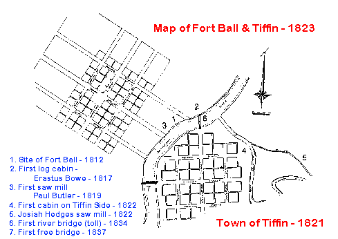 In
1822, Josiah Hedges built the first frame house and saw mill on the Tiffin
side of the river near the juncture of Rock (“Rocky”) Creek. He named his
settlement after his good friend and Ohio’s first governor, Edward Tiffin.
Bitter feelings soon surfaced between the two communities on the opposing
banks of the river. Tiffin, at this time, had very little to offer as compared
to Oakley-Fort Ball. Hedges practically had to give land away to induce
settlement. The elite settled in Fort Ball, while Tiffin just barely survived.
In
1822, Josiah Hedges built the first frame house and saw mill on the Tiffin
side of the river near the juncture of Rock (“Rocky”) Creek. He named his
settlement after his good friend and Ohio’s first governor, Edward Tiffin.
Bitter feelings soon surfaced between the two communities on the opposing
banks of the river. Tiffin, at this time, had very little to offer as compared
to Oakley-Fort Ball. Hedges practically had to give land away to induce
settlement. The elite settled in Fort Ball, while Tiffin just barely survived.
Hedges, not wanting to fail, soon managed
to have Tiffin declared the county seat. Some charged that it was through
bribery of the county commissioners that Hedges succeeded. Whatever the
circumstances, the rivalry became very heated with Spencer and his village
of Fort Ball geographically and politically opposing Hedges and Tiffin
on the other side of the river.
Among one of the points of contention
was a brush dam built by Spencer to hold back the river water for his saw
mill. Hedges claimed that the east end of the dam was anchored to his property.
In 1823, Hedges hired a crew with picks and shovels to dig a channel circumventingl
the Tiffin end of the dam. The channel worked, as the pent-up river water
flowed around the end of the dam, destroying its usefulness. Late in the
year, Hedges was served a summons accusing him of willful damage to Spencer’s
saw mill. After much wrangling, the lawsuit was settled with the court
finding for Spencer and awarding him $8.00 damages plus court costs of
$26.75.
Even the purchase of Fort Ball by Hedges
a few years later failed to allay the sentiment. But the early feelings
of ill will between the two communities were nothing compared to the fever-heat
that erupted in 1829.
Upon the purchase of Fort Ball, Hedges
immediately relocated the post office from the Miami Street area to the
Tiffin side of the Sandusky. Jacob Plane, a friend of Hedges, was named
the new postmaster. A great howl arose from the citizens of Fort Ball.
All kinds of charges and curses were leveled against Hedges, but to no
avail. The post office was to remain permanently in Tiffin, ensuring its
survival.
As of 1833, the population of Tiffin
barely numbered 400 souls. By 1840 it had reached 728, and twenty years
later there numbered 2,718 residents in Tiffin - quite an astounding population
for this part of the country at that time.
For more than fifteen years there was
no bridge to span the river between the two communities. The only way to
cross was by ferry. In 1833, Hedges, seeing new opportunities, contracted
with a local carpenter, Reuben Williams, to build a wooden bridge. So it
was that the first toll bridge appeared the following year at the site
of the present Washington Street bridge.
Later that fall, a heavy rain flooded
the Sandusky. The swollen river carried with it a large number of trees
and a part of another bridge located a few miles upstream. Hedges bridge
could not stand under the onslaught of the flood and was soon swept away.
Hedges, not to be undone, replaced the destroyed structure with a stronger
bridge the following summer.
Although the toll bridge was a great
convenience, towns-people chaffed at the idea of having to pay to cross.
A public subscription of $2,200 was raised, and on February 18, 1837, the
first free bridge opened, spanning the river at Market Street. Being a
covered structure, the new bridge was quite dark at night. After numerous
protests by the ladies of the community, who refused to cross it after
dusk, lanterns were soon placed at either end. Hedges, finding toll collections
had been cut to nothing, soon quit charging for the use of his Washington
Street bridge.
Not only did Tiffin begin to outstrip
Fort Ball in population in the 1830’s, but most businesses soon clustered
around the public square along Washington Street. The town of Tiffin was
officially incorporated on March 7, 1835 by an act of the state. The incorporating
act provided, among other things, for the limits of taxation, for the use
by the town of the county jail, for the building of streets and sidewalks,
and for the purchase of fire apparatus. Little interest was shown in self-government,
however, and the first elections were not held until June, 1836 when Dr.
H. Kuhn was chosen as the first mayor of the town.
The community got a big boost when
the first railroad reached Tiffin in 1841. A spur of the Mad River Railroad,
it was one of many lines that eventually ran through the city, including,
among others, the Cincinnati, Sandusky and Cleveland Railroad; the Tiffin,
Toledo and Eastern Railroad; the Baltimore, Pittsburgh and Chicago Railroad;
the Lake Erie and Louisville Line; and The Pomeroy Road.
Meanwhile, Fort Ball grew very little.
As late as 1848, Fort Ball had no government of its own. Finally, on March
13, 1849, the state legislature passed a resolution allowing for the election
of town officers and fixing the boundary of the village. Jacob Flaugher
was elected Fort Ball’s first and only mayor. His term was short-lived.
Fort Ball ceased to exist in 1850 with its inclusion in the incorporation
of the City of Tiffin on March 23 of that year. William Lang became the
first mayor of the united towns. Tiffin was on its way.
C. 1999, Boroff
Publication Services, Tiffin, Ohio 44883-1644
 .
.