.
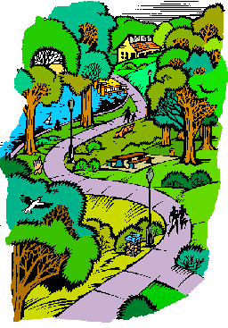
Tiffin's Parks
Tiffin is Founded
The first settler arrived in Seneca County in 1817. Homesteaders settled on the north bank of the Sandusky River. This settlement, Oakley Village, was later renamed Fort Ball in 1820 Josiah Hedges bought a piece of land on the south side of the river and another settlement, Tiffin, was founded in 1822 a court house was established in Tiffin.
Immigrants came, bridges, saw and grist mills, schools, churches, and a railway appeared. in 1850 the communities of Fort Ball and Tiffin merged to form Greater Tiffin.
Highland Park
By 1899 a fifteen-acre grove was being developed as a park. This was Highland Park which no longer exists. It was located at what would now be the intersection of 8th Avenue and Wall Street, extending west to the Maule Road, in what was then known as the Stoner Woods. It was a natural beauty spot, with walks and benches under the trees of the virgin forest. Band concerts and celebrations were held there. The people arrived by the horse-drawn street cars which provided public transportation at that time.
Sobriety at the park was encouraged by a clause which was inserted in the deed of every piece of property north of Fourth Avenue prohibiting the sale of liquor. The newspaper tells of groups meeting in front of St. Joseph’s church and riding to Highland Park for an outing.
Riverview Park
Another popular park in Tiffin in the Victorian Era was known as Riverview. It was located in the area along Ohio Avenue on the Tiffin Center grounds. This park was owned and developed in the early 1890’s by the Yellow Street Car Line, an electric street car line that competed with and eventually took the place of the horse car line.
The expansion of the park encouraged people to ride the cars [fare was 5 cents] and make the street car business more profitable. A six foot picket fence enclosed 25 acres. The enclosure contained a dance pavilion, band stand, tennis courts, bowling alley, snack bar, picnic tables, park benches and playground equipment, as well as a place for boating where a dam on the creek formed a lagoon.
A rustic bridge crossed the creek. This park continued to be a favorite gathering place until the advent of the automobile changed lifestyles drastically. Then Riverview’s popularity declined rapidly, the car line went into receivership, and the property was sold to The Junior Order of Mechanics.
Junior Home Park - Kernan Park
In the late 1890’s Riverview Park and additional farmland was purchased by the Junior Order of Mechanics. This order built a national orphanage which received its first child in 1897. Not only orphans, but children with one parent were taken in. Many important citizens of Tiffin grew up in the Junior Order Home. The highly respected director of the home for many years was “Dad Kernan”
As many as 1,100 children lived there at one time, but the population declined after the passage of the Social Security Act. More mothers were able to support themselves and their children with the aid provided by the act. in 1948 the remaining children were moved to the home in Lexington, North Carolina. The land and buildings were bought by the state for use as a state hospital.
In 1968 the Junior Order Alumni and the city, with the assistance of Senator Turner (whose father was an alumnus), requested that the state return two sections of this land to the city to be used as parks and be named in honor of the Junior Home “Kids” and of Dad Kernan. These two parcels are now the Junior Home Park, located at the intersection of Huss Street and River Road, and Kernan Park, across Ohio Avenue from the Junior Home Park, and bounded by Ohio, Riverside, and Industrial Streets.
The trees in this area were planted by the Rev. Albert Shuman, the minister at the First Reformed Church, and an ardent conservationist. A part of what is now the Junior Home Park was planted with a variety of trees by the lsaac Walton League under the leadership of Mr. Burt Brickner, another of Tiffin’s conservationists. These trees were planted of the Junior Home property on the occasion of Arbor Days and patriotic and other festivities. They were from the birthplaces of Presidents of the United States and other famous places. This is called “Historic Grove.”
Josiah H. Hedges Park
The “Old Cemetery” was at the eastern side of Calvert High School. it became neglected and overgrown with weeds. High water in Rock Creek was also eroding the banks of the creek and exposing the graves.
In 1905 the city obtained a quit claim deed to the land from the heirs of Josiah Hedges. The city paid $12.00 in acknowledgement of the land as a public park, to be known as Josiah Hedges Park. By 1915 the remains from the graves had been moved to Greenlawn Cemetery and the park landscaped and beautified by planting a profusion of peony bushes and trees. Signs were posted warning people to keep off the grass and children were not permitted to play there. Today it is a pretty tree-shaded playground and picnic spot.
Stalter Park
Stalter Park is one-half acre of land located at the intersection of Ohio and Clinton Avenues. It was originally part of the Stalter farm. The farm was divided into lots and sold by David Stalter, who was a city councilman at that time. In 1905 he gave this triangular parcel of land to the city to be called Stalter Park.
Oakley Park
When Tiffin and Fort Ball merged to form Tiffin in 1850, three prominent businessmen, Warren P. Noble, Samuel B. Sneath and J. W. Shaufelberger purchased areas of the land north of the river. In 1888 when Tiffin came into its own with the discovery of natural gas, the land was sold as lots for homes and locations for industries, and six acres, bounded by Grand, 6th and Park Avenues were given to the city by the three owners; to be known as Oakley Park to commemorate the village of Oakley, the first named settlement of Tiffin.
Hedge-Boyer Park
Picturesque Rock Creek winds through Hedges-Boyer Park, the largest park owned by the city. Rock Creek was well known to Tiffin children long before the city owned the land - the “old swimmin’ hole” was there.
In those days, the creek contained more water than at present, and more importantly, the water was cleaner. Young “Tom Sawyer” spent many hot summer afternoons along its banks. Girls swam at a shallow place known as “Baby Hole” and the boys, usually without suits, swam at deeper holes upstream.
A young man built a renowned tree house in the willows along the creek. The first platform was 35 feet above the ground. There were several others even higher, all connected by catwalks with railings. The willow trees supplied all the buiding material, and one railing spelled out the words “Welcome to Willow House.” After a few years this unique structure was neglected and finally removed.
The purchase of this land, the one hundred acre Haverstick farm, was made possible by a bequest of William Hedges, a grandson of Josiah Hedges. William Hedges and his wife, whose maiden name was Boyer, left their Mansfield home to the city. The home was sold and the money was used to buy the farm in 1940. Landscaping and planting have beautified it.
The statue of Josiah Hedges which originally adorned the courthouse lawn was moved to its present position at the gate. Picnic shelters, baseball diamonds, tennis courts, and a swimming pool have been added to make this an outstanding recreation area.
Two of the baseball diamonds are named in memory of men who worked to promote baseball in Tiffin, Vic Wurm and Ralph “Jocko” Huffman. Roger Young field is named for a WW II hero from Fremont. The indoor Community Pool, standing adjacent to the park, on land donated by Heidelberg College and built and maintained by funds from the National Machinery Foundation, adds to the value of this area.
North End Park
Three adjacent parcels of open farmland were purchased with local funds in 1975 and 1976 to form a seventeen acre park known as the “North End Park.” Plans for the development have been divided into three phases.
Phase I will include an outdoor pool complex with grassy sunbathing areas, and multi-purpose game courts. Phase II includes parking lots, horseshoe, basketball, tennis and volleyball courts, an ice skating area, Picnic facilities, shuffleboard, and play areas. In Phase III, game fields, a play area, an earth mound and a shelter will be constructed The park has not yet been developed, named, or dedicated.
East Davis Park
The last segment of the potentially beautiful East Davis Street Park, along the Sandusky River, was acquired by the city in 1976. This 26-acre area has a tragic history. The land between Elwood Street and Davis Street was the Weott lime quarry at the beginning of the century.
The 1913 flood filled the quarry with water and washed the homes of several families there. Fifteen residents of this area were drowned in the flood and homes were not rebuilt. The city used the quarry as a dump until it was filled and leveled. The Park Board plans natural trails along the banks of the river, and a picnic area in the open space.
Applejack Park
Applejack Park takes its name from its location, the intersection of Apple and Jackson Streets. it was originally an apple orchard.Iit became the property of the Tiffin School Board, which had plans to build a high school there. It was not used for this purpose, but was used by the high schools, both Calvert and Columbian, as a football field, until the new stadium was built at Columbian High School in 1939.
The Junior High Schools continued to use it as a football field until 1972. In 1972 the Meshech Frost Foundation donated $28,000 to the Tiffin Park Board for the purchase of Applejack as a city park. initial development of the park was accomplished with the help of the Lions Club, The Junior Women’s League and the Town and Country Garden Club and neighborhood volunteers. The equipment now in the park was provided by the Park Board.
Neighborhood Parks
Riverview Park, located at Gail Lane and Longfellow Drive, was given to the city by Herbert and Garnet Brauchla in the spring of 1955, after the Riverview subdivision was completed. It is a neighborhood playground.
Westgate Park, located at the intersection of Ashwood and Beechwood Drives, was deeded to the city by the developer of the Westgate area in 1972. The Park Board provided playground equipment and has plans for tennis courts there.
Park No. 5 is an undeveloped piece of land on East Market Street. During World War II the federal government used this land for grain storage. When this was no longer necessary, the city acquired the land by application to the federal go vernment with the stipulation that it be used as a park.
The Scenic River Project
When the Scenic River Program was made possible through funds provided by the Federal government, Senator Gillmor was instrumental in having the Sandusky River designated as a scenic river. It was the second river in Ohio to be so designated (1970).
The scenic river program in Ohio is administered by the Department of Natural Resources, the Division of Natural Areas and Preserves. Under the Revised Code, this division is to “create, supervise, operate, protect and maintain wild, scenic and recreational areas.” A local advisory board is appointed by the Department of Natural Resources. it is made up of 10 citizens from the three counties the river runs through – equally from each of the political parties.
The board advises the Department of Natural Resources on what is desired by local people. Fifty per cent of the money to buy and develop these areas comes from federal grants. The Director of the Department of Natural Resources cooperates with federal agencies and administers the funds; he can make agreements with political subdivisions to administer programs.
Initially in 1970 there were two land purchases: two hundred eighty four acres at Heck’s Bridge was the first purchase in Ohio under this program. It is called Howard Collier State Park. Mr. Collier was the state Finance Director at that time and was instrumental in acquiring the funds for the purchase. A portion of it has been developed into a picnic area. The larger part will probably always be a wildlife refuge.
The second of the two initial purchases was made in the Wolf Creek area, in Sandusky County. it consists of 90 acres that has been developed in to a picnic and camping area. The Isaac Walton League has donated 17 acres along the river and Mr. Burt Brickner donated another 3 acres. This is on the west bank of the riverjust north of Tiffin. In 1975, 40 acres were bought on Township Road 152, east of Fort Seneca, on the west side of the river just across Abbot’s Bridge. This gives access to the river, which is deep from this point all the way to Fremont.
c. 1998 Boroff Publication Services, Inc., Tiffin, Ohio